
Ino’s Documents appointed as NATIONAL TREASURES
IT HAS BEEN almost 200 years since Tadataka Ino (伊能忠敬) passed away. Tadataka made the first accurate coastal maps of Japan. He was born at Katori City, Chiba Prefecture in 1745.
It took Tadataka nearly 16 years to complete his project. He walked 3700 days and took 40,000,000 steps along Japan’s coastline, nearly 44,000 km, longer than the equator. Tadataka traveled 230 out of 365 days, and averaged 12km a day.
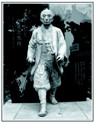
In honor of his remarkable feat, a statue of Tadataka stands at Tomioka Hachimangu,
Fukagawa, Tokyo, where Tadataka wished for travel safety at every departure. The stick Tadataka carrys is not a walking stick! It is called Wankarashin (彎窠羅鍼), a stick with an azimuth compass and leveler. Tadataka’s achievement was inherited throughout the Meiji, Taisho, Showa eras and had a big impact on the development of map science.
Today there are only two scrolls existing in the world which depict his work. They are Urashima Sokuryo no Zu (1806) and Mitarai Sokuryo no Zu (1806). Both are located in Kure city.
Recently, Takehisa Igaki (井垣武久) from the Kure Board of Education, found some similarities in a painting by local artist Kiyoshi Asai and the scrolls. He identified the mountain depicted in the Urashima scroll as Mt. Shiratake in Hiro. Some neighboring islands in the Seto Inland Sea were also narrowed down. It revealed that Tadataka’s measuring took place in the Nagahama, Hiro, Aga and Ondo districts.
“A painter must have accompanied Tadataka and painted the scenes,” says Takehisa. Among his many assistants was a sword carrier. A steel sword has the capability to influence compass readings so Tadataka wore a bamboo sword while working. His attendant held the real sword for him.
Since the fifth delegation, the Shogunate sponsored Tadakata’s map work. A number of clan officials and village helpers made a long procession and accompanied Tadataka.
This March, 2345 items of documention, maps and drawings were designated as National Treasures. The scroll Urashima Sokuryo no Zu is kept at Irifuneyama Museum (Important Cultural Property) in Kure.


Photos Top: Tadataka statue, Tomioka Hachimangu, Tokyo
Left: Japan coastlines as traveled by Tadataka
Right: Part of Urashima Sokuryo no Zu drawn in Bunjinga style (Chinese style)
伊能忠敬の文献、国宝に指定
伊能忠敬没後、約200年が経つ。 忠敬は日本で初めて正確な沿岸地図を作った人物で、生まれは1745年、千葉県加鳥市である。
忠敬は16年近くかけて、この事業を成し遂げた。赤道よりも長い日本の海岸線、約44,000kmを、40,000,000歩3700日かけて歩いた。 365日のうち230日を歩き、その移動距離は1日平均12kmになる。
偉大な功績を称えて、忠敬像が東京都深川市富岡八幡宮に立つ。そこは忠敬が出立する際、旅の安全を祈った神社である。忠敬は棒を持って歩いていたが、それは杖ではない。方位コンパスと地ならし機を備えた「彎窠羅鍼」と呼ばれる棒である。 忠敬の偉業は、明治・大正・昭和へと受け継がれ、地図科学の発展に大きく寄与した。
現在、事業の成果である絵巻は2点しか存在しない。浦島測量の図(1806)と三鷹測量の図(1806)で、どちらも呉市にある。
最近、教育委員会の井垣武久さんは、地元の朝井清の絵画と忠敬の絵巻が似ていることに気づいた。浦島絵巻に描かれている山が、広の白岳山だと考えられ、瀬戸内海の近隣の島も確定されている。忠敬の測定が、長浜、広、阿賀、音戸地区で行われたことが明らかになった。
「画家が忠敬に同行し、景色を描いたにちがいない」と井垣さんは言う。助手の中に、刀持ちもいる。鋼の剣はコンパスの読みに影響を与える可能性があるため、忠敬は作業中は竹刀を身に着け、付き人が代わって本物の剣を持っていたのである。
第5回測量隊以降、幕府は忠敬の地図作成に資金援助をしている。多くの藩士や村人たちが長い行列を作って忠敬に同行した。
今年3月には、2345件の文献、地図、絵画が国宝に指定された。浦島測量の図は呉の入船山記念館(重要文化財)に保管されている。